

Faculty: Richard Becker, Ph.D.
Professor
Ph.D., Western Michigan University 2008
M.A., B.A., Washington University
Research and Teaching Interests
Environmental applications of remote sensing and GIS, including:
419.530.4571 | richard.becker@utoledo.edu
Research View Dr. Becker's Publications
Courses View Vitae
Research
 At the Environmental Remote Sensing Lab, we undertake research which incorporates
an interdisciplinary research approach (remote sensing, geochemistry, hydrologic modeling,
and field techniques) to investigate a wide range of geological and environmental
problems including the assessment of responses of natural systems to climatic and
human activities.
At the Environmental Remote Sensing Lab, we undertake research which incorporates
an interdisciplinary research approach (remote sensing, geochemistry, hydrologic modeling,
and field techniques) to investigate a wide range of geological and environmental
problems including the assessment of responses of natural systems to climatic and
human activities.
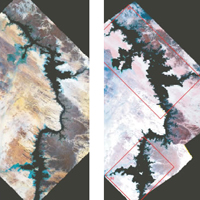
Examples of these include: Identifying and mapping potential harmful algal blooms from satellite images, and examining impacts of land use change on blooms and other systems in the Laurentian Great Lakes. In addition we study the impact on the Nubian aquifer in Northeastern Africa and Nile watershed of the construction of the Aswan High Dam, from changing recharge in the system to changing subsidence in the Nile Delta, to investigating the effects climate change has had on this system.
To do this we utilize a variety remote sensing and GIS techniques to investigate water resources and the impacts that human use may have on them.
More information: Dr. Becker's lab webpage.
BACK TO TOP ⇑View Dr. Becker's Google Scholar page.
Courses
- EEES 1050 ENVIRONMENTAL HAZARDS [3 hours] Introduction to hazardous geological processes and materials: volcanic
eruptions, earthquakes, floods, ground subsidence and collapse, landslides, coastal
flooding and erosion and others. Causes and risk mitigation are discussed. [Fall,
Spring, Summer]. Natural Sciences core course. (Spring and Summer are offered in a
Distance Learning format.)
- EEES 2100 FUNDAMENTALS OF GEOLOGY [4 hours] Consideration of earth materials and the dynamic external and internal
processes active on earth; the physical and biological history of the earth. [Fall,
Spring] Prerequisite: CHEM 1090 or 1230.
- EEES 6980 GIS FOR ENVIRONMENTAL SCIENCE
- EEES TBD ENVIRONMENTAL REMOTE SENSING