

Parks and Gardens
Experiential Learning Module: Parks and Community Gardens
BIG QUESTION
What recreational opportunities (Parks and Community Gardens) are available in your Neighborhood?
OVERVIEW
Parks and community gardens give the public opportunities to exercise and relax. The distribution of recreational opportunities is not evenly distributed. In some locations, the distribution of parks and community gardens was determined historically through biased approaches. Some neighborhoods have very few parks and community gardens while others have many more opportunities. The placement could be due to socio-economic or racial considerations where more well-off areas of a city will have more recreational opportunities or areas with traditionally underrepresented groups will have less recreational opportunities.
Content focus: Social Science, Geography, People-Environment, Population
Skill focus: Map Interpretation, Remote Sensing, Fieldwork and Observation, Data Analysis
Level of Inquiry: Confirmation through Open Inquiry
Key Concepts: Environmental impact, Urbanization, Urban planning, Vegetation cover, Green space, Remote sensing
Grade Level: 9th to 12th grades
Duration for Lesson: 4 to 7 days
Module summary by section:
Engage-
- Students are asked to describe images of community gardens. Students discuss what makes a park and community gardens.
Explore-
- Students map parks and community gardens in their neighborhood. Use Google Earth to determine where other parks and community gardens may be that the students did not have in their list.
Explain-
- Walkability: Can students use the park: Use Google Earth to determine if there are barriers for students to use the parks or community gardens such as a busy road, railroad track, fence, or dangerous situation.
- Plan field work and then visit parks by walking around the neighborhood
Materials – camera, GPS unit, notebook to take notes, etc.
- Use GPS to get latitude and longitude.
- Describe what is in the park.
Extend-
- Bring park locations into ArcGIS Online.
- Relate parks and community garden locations to demographic information in ArcGIS Online.
Connections-
- How available are parks and community gardens to your students versus students in other neighborhooods? What are the possible causes for any differences in the lack of or the abundance of parks in gardens in the community?
STANDARDS
Focus Standards
Next Generation Science Standards
HS-LS2-7. Design, evaluate, and refine a solution for reducing the impacts of human activities on the environment and biodiversity
Disciplinary Core Ideas
When evaluating solutions it is important to take into account a range of constraints including cost, safety, reliability and aesthetics and to consider social, cultural and environmental impacts.
Moreover, anthropogenic changes (induced by human activity) in the environment—including habitat destruction, pollution, introduction of invasive species, overexploitation, and climate change—can disrupt an ecosystem and threaten the survival of some species. (HS-LS2-7)
College, Career, and Civic Life
D2.Geo.2.9-12. Use maps, satellite images, photographs, and other representations to explain relationships between the locations of places and regions and their political, cultural, and economic dynamics.
National Geography Standards
Geography Standard 14. How human actions modify the physical environment
Prior Standards: Anticipated Prior Knowledge
Next Generation Science Standards
MS-ESS3-3. Apply scientific principles to design a method for monitoring and minimizing a human impact on the environment.
College, Career, and Civic Life
D2.Geo.1.9-12. Use geospatial and related technologies to create maps to display and explain the spatial patterns of cultural and environmental characteristics.
LEARNING TARGETS
By the end of this module students be able to use remotely sensed imagery and field observations to identify parks and community gardens. Students will understand the concept of Walkability. They will be able to use geographic mapping software to analyze data layers and understand how the distribution of parks and community gardens relates to demographic data of race, ethnicity, and socio-economic standing.
Are there Recreational Activities Nearby?
CONTENT BACKGROUND:
“The right of everyone to enjoy and benefit from a safe and healthy environment, regardless of RACE, CLASS, GENDER or ETHNICITY.” (Gregory et al. 2009)
Recreation and exercise are important for children to develop fully social and physical skills. One function of local and city governments is to provide quality of life opportunities for its citizens. Recreation through parks and community gardens is one such quality of life determinant.
Forms of parks and community gardens vary in different parts of the country and world.
National Parks – Arches National Park Utah Playgrounds – Browns Berry Patch, NY


State Park – Letchworth State Park, NY City Park – Galliers Park, Toledo, Ohio


Community Gardens – Toledo, Ohio Sports Fields – soccer field Temperance, Michigan


Parks and community gardens take on many different sizes and shapes and can be maintained by many different entities ranging from the federal government to local volunteers.
ENGAGE
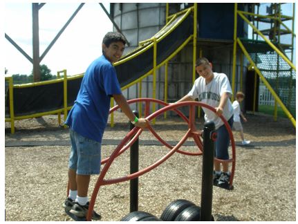
What do students consider a park or recreational area? Show the pictures above and have students discuss whether it is a park, community garden or neither.
Student Resource I: Defining a Park Activity 1
[Note: Student Resource I includes the following six steps]
1. Write a one to two sentence definition of a “Park.”
Students may identify playground equipment of sports fields as constituting a park. However, there are many types of parks as shown in the images above in the Content Background section.
2. In a small group, write a definition of a Park that you all agree upon.
As students discuss the definition of a park, they may see that their definitions are different. If they are all similar, the teacher may want to give examples of other types of parks. The students may never have been to a state or national park for instance.
3. How does the class definition compare to this definition? How are they similar and how are they different?
Help the students see that the definition of a park may also be different from location to location.
4. Imagine 20 years from now – How do you anticipate your city changing over time? (In a group of 3, students can brainstorm and come up with how they might see their city changing over time)
Defining a Community Garden
Social Impact of Community Gardens
http://escholarship.org/uc/item/6bh7j4z4
4. Write a one to two sentence definition of a “Community Garden.”
Similar to the exercise for parks above, have students define a community garden. Again, their definitions may not match. Use the images from Google Earth showing different community gardens from Switzerland compared to the United States.
5. How is a Community Garden Different than a Park?
Sometimes it is hard to tell the difference between a community garden and a park. In appendix A, figure 4 shows an arboretum. It may be considered a community garden because it is a garden of trees. However, it may be used more like a park where the public walks through it. There is a gazebo as well as walking paths similar to a park.
6. Draw a mental map of the neighborhood that includes parks and community gardens.
(What is a mental map? Mental maps are a mix of objective knowledge and subjective perceptions: precise knowledge about the location of geographic features as well as impressions of places, rough estimates of size and location, and a general sense of the connections between places. (Source: National Geography Standard 2: www.nationalgeographic.org/education/standards/national-geography-standards/2/)
Activity 2: What is a park and a community garden?
- List up to six factors that make a park.
|
Factor |
Rank |
These could be whatever the students come up with.
Some factors include: park benches, picnic tables, paths for hiking/walking, parking, pavilions for parties, sports fields, ponds, wooded areas, golf course to name a few. There is no right answer.
2. Rank these in order of importance to you with 1 being most important and 6 being least important. Write the numbers in the box to the right of each factor.
What is a community garden?
3. List up to six factors that make a community garden.
|
Factor |
Rank |
This may be harder for the students to develop as many of them may not have seen a community garden. Community gardens may have vegetables and flowers. They may be in rows or raised beds but they may not. Some community gardens have square plots while others do not as well. Some community gardens may resemble a park to a large extent. Again, there are no right or wrong answers.
4 Rank these in order of importance to you with 1 being most important and 6 being least important. Write the numbers in the box to the right of each factor.
EXPLORE
This is an Individual activity:
Using Google Earth to find parks and community gardens in your neighborhood. (To download and install Google Earth link XXX)
Exploring Your Neighborhood Virtually (Student Resource II)
The purpose of this activity is to explore the neighborhood around your school virtually through an on-line source. We will use Google Maps (https://www.google.com/maps/) to verify parks and community gardens that you knew about as well as look for others that may be present but you did not know about. The student worksheet asks the student to identify parks and community gardens in an area that the teacher assigns. This is up to the discretion of the teacher. If you prefer, the students could investigate the entire area around the school. (Note: The table and questions below are provided in Student Resource II)
To get the coordinates of a place:
- Open Google Maps. If you're using Maps, you’ll see a lightning bolt at the bottom and you won't be able to get the coordinates of a place.
- Right-click the place or area on the map.
- Select What's here?
- At the bottom, you’ll see a card with the coordinates.
(Source: https://support.google.com/maps/answer/18539?co=GENIE.Platform%3DDesktop&hl=en)
You can zoom in to see things closer. Your teacher will assign an area of the neighborhood to explore.
- Identify places in your assigned area that may be parks or community gardens. Note the latitude and longitude.
|
|
Latitude |
Longitude |
Identifiers |
|
1 |
|
|
|
|
2 |
|
|
|
|
3 |
|
|
|
|
4 |
|
|
|
|
5 |
|
|
|
|
6 |
|
|
|
2. Review the map that you drew by hand prior to using Google Earth. List the areas that matched and the ones that did not?
The comparison of the maps is up to the students’ determination. There is no right or wrong answer.
Student Resource III: Walkability of your school’s neighborhood
(Student Resource III provides a worksheet for this activity)
Now that you have found places that may be parks and community gardens, assess the walkability of the school’s neighborhood. The walkability is related to the safety of walking to places in the neighborhood. Are there barriers to going to a park such as a large road or water body?
There are many benefits of walking and walkable neighborhoods, whch often have a huge demand for housing. Low income residents have a dearth of these walkable neighborhoods with crime, poor market strength and racial segregation negatively influencing the factors of walkability. (https://www.huduser.gov/portal/periodicals/cityscpe/vol17num2/ch1.pdf).
Go to the following website: https://www.walkscore.com/
Type in the address or your school and get the walkability score: the higher the score is the better the walkability of the area. (Example: Downtown of San Francisco has a walkability score of 98)
Walkability Score: ______________________
1. Find five areas that are different than the area around your school and find the walkability score.
|
Location |
Location Description |
Walkability Score |
|
1
|
|
|
The students should feel free to explore. They should look at locations that they are interested in. Some examples are Disneyland, Chicago downtown, Downtown Detroit, Subarban areas around cities.
2. Go back to Google Maps. Looking at the imagery, identify barriers for students at your school to visit parks and community gardens nearby.
Although the walkability of the neighborhood around your school may be high, there may be barriers for students to walk to parks or community gardens.
3. Are there any potential locations where community gardens or parks can be added?
Student Resource IV: Exploring Your Neighborhood through Fieldwork
(This activity could be done in a group and Student Resource IV is a worksheet for class)
The purpose of this activity is to explore the potential parks and community gardens of your neighborhood that you identified with Google Earth and see if they are parks and community gardens as you thought.
Important Note: Please do not trespass on people’s properties. All of your observations should occur from public sidewalks or streets only.
List the factors that make this parcel a park or community garden (What is a parcel of land? It is a measured portion of land. Source: https://www.reference.com/science/parcel-land-f8c30b208d6c3cd8?qo=contentSimilarQuestions)
|
Parcel 1 Lat long |
Parcel 2 Lat long |
|
Factors |
Factors |
|
1. |
1. |
|
2. |
2. |
|
3. |
3. |
|
4. |
4. |
1. Overall, does your field work support the virtual investigation you completed? Were the locations you identified as parks and community gardens actually them?
Extend
Student Resource V: Secondary Data and Gather Data Layers using ArcGIS or ArcGIS Online
(Student Resource V is a worksheet for this activity)
Step-by-Step Instruction to use Arc GIS online:
This is a step-by-step exercise that your students should be able to do on their own. This will take preparation on your part. You will need to do the following before having the students do this part of the exercise.
1. Get ArcGIS installed or get access to ArcGIS Online. ArcGIS Online is a lot easier to get up and running.
Step 1: To login
Go to https://www.arcgis.com/
Your teacher will need to set up an ArcGIS account for you. Once you have an ArcGIS Online account, you can do the following.
Step 2: Selecting a map
On the top of this page, you see the following tabs: Home, Gallery, Map, Scene, Groups, My Content, My Organization
Click on the word “Map”
Your screen should look like this: 
Step 3: Selecting a Base Layer
What is a base layer?
A base layer is the reference map. On top of the base layer we can add, delete, find and do all other operations on the map. It is the same as the basemap that you will choose in this step.
To add a Base layer:

On the top left of this screen, click on the option Basemap (circled in the above image) and you will have different options to choose from.
Click on the second option, Imagery with Labels.
Zoom in on your location and you can explore some of the features on the surface of the earth.
EXAMPLE:
To use the data students have collected as a base layer:
Go to Add layer from file.
Add your excel file (Parks) onto the map.
Select the basemap option: Imagery with Labels
Zoom to see Your Location (look at the example below in step 4).
Step 4: Adding a layer to the base map
Users can choose where they want to search for layers— My Organization, The Web, A GIS Server, ArcGIS Online, Esri Map Layers, My Content, My Favorites, or groups you belong to.


Click on the “Add” button at the top of the right side of the page (circled in red), this will let you add layers.
Choose “Search for Layers” from the dropdown menu and use a keyword you would like to use within the Find field.
Find: Income_Extremes In: ArcGIS Online
Notice that the “Within map area” is checked. This tells you that the analysis will be done only in the area that you can see on the map. If this is left unchecked, analysis will take place for the full map.

OR
Click on the first title “Income_Extremes” by esri to see a pop-up summary of the layer. This provides information about what you can see in the map. From here you can add the layer by choosing “Add to map.”

Finally- Go to the bottom of the left column and choose, “Done Adding Layers.”
Connect
Student Resource VI: Parks and Community Gardens and Social Justice
Studies have revealed that white and wealthy population communities predominantly have more green space. Having access to green space is an environmental justice issue. Strategies are implemented in many cities to increase green space in the neighborhoods focusing mainly on areas with no or very less parks. http://ced.berkeley.edu/downloads/research/LUP.parks.pdf
Mapping Parks and Community Garden Locations Using Online Mapping
Enter the Parks and Community Garden latitude and longitude into an Excel file.
Open ArcGIS online and add the Parks and Community Garden data into ArcGIS.
Given the location of parks and community gardens, compare data layers from the webpages below to investigate if the location and availability of recreation near your school could be related to race or ethnicity.
In ArcGIS Online, bring in the following layers:
2012 USA Population Density
Now that we’ve considered factors that affect Social Justice and explored parks and community gardens in your community, please write three paragraphs, double-spaced in response to this question:
How does the condition and availability of Parks and Community Gardens relate to social justice?
Using ArcGIS online, bring up data layers and then find the answer to these questions. In ArcGIS Online, use the “Add” button to add the layers. Search for them by choosing “In ArcGIS Online”. You may have to look at the Attribute table.
- 2012 USA Population Density (Mature Support) – This data is mapped by block group and county depending on how close up you are (an area). – Which block group (number) in (insert your location) has the highest population density in 2010?
2. USA Wildfire Activity – This data is mapped as a point, i.e. the location of the fire. What is the closest currently occurring fire to (insert your location)? And, how far away is it?
3. 2012 USA Median Household Income (Mature Support) – This information is by block group and is represented by an area. What is the US median income?
4. 2012 USA Median Age (Mature Support) – This data is by block group. – What is the range of median age for the block that (insert your school here) is in?
5. Have a final discussion session about their findings and conclusions.
Teacher Resources
|
Item |
URL |
Purpose |
|
|
Definition |
http://www.dictionary.com/browse/park |
Definition of parks from dictionary.com |
|
|
Background |
http://escholarship.org/uc/item/6bh7j4z4 |
Journal article on the benefits of having a community garden in the neighborhood. |
|
|
Background on mental maps |
www.nationalgeographic.org/education/standards/national-geography-standards/2/ |
All information related to mental maps |
|
|
Data |
Google Maps |
It is a virtual tool by google that helps in collecting and mapping data |
|
|
Information on walkable neighborhoods |
https://www.huduser.gov/portal/periodicals/cityscpe/vol17num2/ch1.pdf |
Journal article that discusses the analysis of affordable housing and walkable neighborhoods |
|
|
Walkability Calculator |
https://www.walkscore.com/ |
Website that calculates the ability to walk around in the neighborhoods |
|
|
Mapping |
https://www.arcgis.com/ |
Online mapping tool that customizes primary and secondary data. |
|
|
Information on parks and neighborhoods |
http://ced.berkeley.edu/downloads/research/LUP.parks.pdf |
Journal article that discusses parks are being implemented in areas that have very few or none |
|
STUDENT RESOURCES
(This is a list of all of the class worksheets that are included in the module above)
Student Resource I - Defining a Park and Community Garden
Student Resource II - Exploring the Neighborhood Virtually
Student Resource III - Walkability
Student Resource IV - Exploring the Neighborhood through Fieldwork
Student Resource V - Secondary Data and ArcGIS
Student Resource VI - Environmental Justice
ADDITIONAL RESOURCES
http://www.newcommunities.org/cmadocs/egarfieldqofl2005.pdf
Urban Agriculture, the Bronx - http://digitalcommons.lmu.edu/cgi/viewcontent.cgi?article=1049&context=cate
Community gardens : Toledo Grows is the best! It has all information related to all gardens in Toledo, Ohio. http://www.toledogarden.org/toledogrows/community-garden-listing/.
Social Impact of Community Gardens
http://escholarship.org/uc/item/6bh7j4z4
Urban Green Space, Public Health, Environmental Justice
http://www.sciencedirect.com/science/article/pii/S0169204614000310
Newspaper article: The crisis in Britain’s parks is a social justice issue - https://www.theguardian.com/commentisfree/2016/sep/29/britains-parks-green-spaces-poor-young
Research paper (Attached) : Access to Parks for Youth as an Environmental Justice Issue: Access Inequalities and Possible Solutions : (Authors : Alessandro Rigolon * and Travis L. Flohr): www.mdpi.com/2075-5309/4/2/69/pdf
Newspaper article : Gardening for Social Justice : http://www.gardeners.com/how-to/gardening-for-social-justice/5217.html
Newspaper article : Slamming the Door on Low-Income People? : http://www.perc.org/articles/slamming-door-low-income-people
Research paper: (Paper is available with the link – no downloading required): Economic Inequality, Poverty, and Park and Recreation Delivery: Public parks and recreation leaders are encouraged first to develop positive relationships with influential allies when advocating for improved leisure service delivery. : http://people.tamu.edu/~dscott/340/U3%20Readings/3%20-%202013%20JPRA%20-%20Economic%20Inequality.pdf
Website: Fighting Poverty with Parks: http://futureecon.com/future-economy/fighting-poverty-with-parks/
Website : This article is in Uganda, but has a very different take on the subject: http://news.wisc.edu/poverty-and-national-parks-decade-long-study-finds-surprising-relationship/
Research paper (Paper is available with the link – no downloading required): Spatial Disparities in the Distribution of Parks and Green Spaces in the USA: https://www.ncbi.nlm.nih.gov/pmc/articles/PMC3590901/
Website :Map illustration is good. : http://www.greeninfo.org/work/project/park-access
Website: http://activelivingresearch.org/disparities-park-space-race-and-income
Gregory, D., R. Johnston, G. Pratt, M.J. Watts, and S. Whatmore, 2009. The Dictionary of Human Geography, 5th Edition. P. 201.
Walkability:
News paper article : How Walkable Communities Are Good for Us: http://www.huffingtonpost.com/f-kaid-benfield/how-walkable-communities_b_6014028.html
Website : Step It Up! The Surgeon General’s Call to Action to Promote Walking and Walkable Communities : https://www.surgeongeneral.gov/library/calls/walking-and-walkable-communities/exec-summary.html
Website: Social Equity Benefits of Walking : http://americawalks.org/learning-center/benefits-of-walking-2/social-equity/
Website: A little game : Walk score: https://www.walkscore.com/walkable-neighborhoods.shtml
News paper article: We want more walkable neighborhoods: but can our communities deliver? : http://www.huffingtonpost.com/f-kaid-benfield/we-want-more-walkable-nei_b_8678134.html
News paper article: Study: Dallas is one of the worst 'walkable urban' cities in the country, but doesn't have to be : http://www.dallasnews.com/news/dallas-city-hall/2014/06/17/study-dallas-is-one-of-the-worst-walkable-urban-cities-in-the-country-but-doesnt-have-to-be
Website: Exploring the Inner-city Paradox: Poverty, Neighborhood Walkability, and Obesity: Standard urban form measures cannot explain these disparities; by these measures, poor urban neighborhoods tend to be more walkable than no poor neighborhoods. http://activelivingresearch.org/exploring-inner-city-paradox-poverty-neighborhood-walkability-and-obesity
Website : Why Walkability comes at a price? https://parksify.com/why-walkability-comes-at-a-price-da9bdc2523db#.syjtbbyxi
Website : Driven into Poverty: Walkable urbanism and the suburbanization of poverty: http://citytank.org/2013/03/08/driven-into-poverty-walkable-urbanism-and-the-suburbanization-of-poverty/
Appendix A:
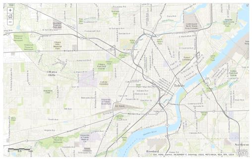
Current and Historical Remotely Sensed Image of parks and community gardens in Toledo, Ohio.
How to retrieve Remotely Sensed Images Using Google Earth:
Assuming Google Earth is available on the computer, enter the address of the school. [If not, this is a free program that can be downloaded: https://www.google.com/earth/download/ge/agree.html .]
For our example: 2400 Collingwood Blvd., Toledo, OH
Parks and Community Gardens
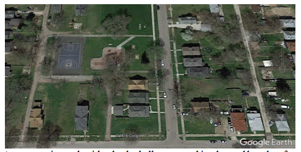
A community park with a basketball court, parking lot and benches for picnics.
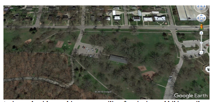
A city park with a parking area, pavilion for picnics and hiking trails.
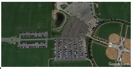
Sports fields – note the lines for soccer fields, the infield and fences for softball and the parking areas.
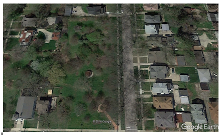
Community arboretum
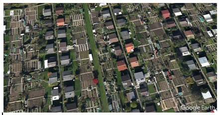
Community garden in Switzerland
